The Solutions Page
Using Garmin GPS In Eastern Europe
Background
Garmin use two type of maps in their GPS units. A "basemap" and a "detail map". The basemap shows major roads and provides similar detail to the average paper road atlas. The detail map shows ALL roads in areas where detail maps are available..
Most of Western Europe has 100% coverage with the detail maps but in Eastern Europe the coverage varies. For example, with City Navigator 8 Poland had partial detail map coverage but 100% coverage with CN 9. Other countries such as Slovakia had no detail maps in CN 8 but there is limited coverage in CN 9. There are areas where the detail map coverage is so limited that it does not even include all the major roads shown on 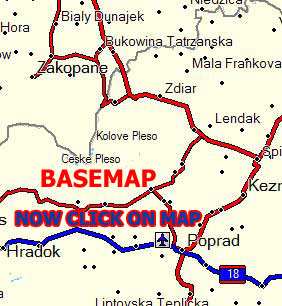 the base map. the base map.
The differences in coverage can be seen in Mapsource (or the gps) by changing the scale of maps. Using CN 9 in Mapsource view a section of Slovakia in high resolution at 15 mile scale. Now zoom in to 7 mile scale. One would expect more roads to be shown but the opposite is the case, even some towns disappear. This is because at 15 mile and smaller scales Mapsource uses the basemap but at larger scales it uses the detail map - which does not include all roads or places.
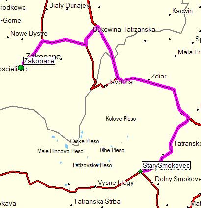
The map on the left shows a section of the Poland - Slovakia border. Click on it and the same area is shown as a detailed map. Many roads and places in Slovakia now diappear as the detail map does not include them BUT in Poland an extra road is shown to the West of Zakopane and more towns appear as Poland now has 100% detail mapping.
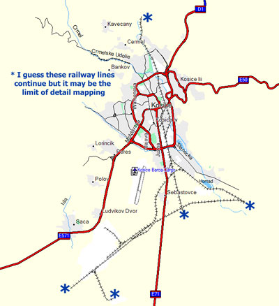
Zooming into most towns brings up more minor roads and other features but it is noticeable that linear features such as railways lines stop in the suburbs of towns although the line clearly must go somewhere. My own interpretation of this is an indication of the limit of detail coverage.
When it comes to calculating a route Garmin software will use a detail map when available, otherwise it uses the base map. This becomes a problem in countries such as Slovakia. As a detail map exists the software uses that although some major roads only appear on the basemap. An example of how this affects routing was found when directions were wanted from a town in Poland to a town in Slovakia. Using CN 8 the route was 33 miles long. Using CN 9 the route became 107 miles!!. The two towns are connected by a major road which is not included in the Slovakia detail map so Mapsource cannot use it.
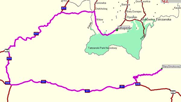
Here is the route calculated in City Navigator 8. It is a reasonably direct 33 mile route. It is what would have been chosen using a recent paper map and passes through a 24 hour border crossing.
Here is the same start and finish points but with City Navigator 9 in use. Nothing else has changed. I simply switched Mapsource to CN9 and clicked recalculate. The route is now 107 miles and, as can be seen, the road used on the CN 8 route no longer exists on the map south of the Polish border.
The Workaround
In Mapsource
If both CN 8 and CN 9 are available install both in Mapsource and switch to CN 8 for Eastern Europe routes.
On the GPS
This example refers to a Streetpilot 2720 but other units are probably similar. The GPS cannot hold both CN 8 and CN 9 so there will be a problem in transferring a Mapsource route calculated in CN 8 to a GPS using CN 9. As the GPS will want to use the detail maps, as with Mapsource, it ignores the basemap roads. It will ask to recalculate the route which, in the example above, changes the perfectly drivable 33 miles into 107 miles. The solution is to answer NO when it asks to recalculate. The result will be a perfectly good route but the map will show it as lines across country without any roads shown. This is probably enough to drive it but there is another tweak.
In the menu on the satnav turn off CN 9. These seems a bit drastic as it is the only map shown as installed but in fact it only turns off the detail maps, the basemap still exists so the missing roads are shown again and the gps will use them to navigate.
As some roads are on the basemap and not the detail map and others on on the detail map and not the basemap it may be necessary to experiment when setting routes directly on the gps. It is likely that some will be better with CN 9 enabled and others will be better with CN 9 turned off. It all depends on what roads are available on the chosen mapping. For long distance route between towns which are likely to use main roads it is probably better to disable CN 9. The detail maps seem better inside towns so its probably better to have CN 9 turned for short town routes or finding small roads.
Disclaimer.
The information on how the gps calculates routes using detail maps and basemaps and how the maps change depending on scale has been confirmed in a telephone conversation with Garmin UK who also accepted that the limitations of detail maps coverage in Eastern Europe can cause routing errors.
Garmin also advised that there is no guarantee that routes calculated on basemaps are practical as those maps may not have been surveyed recently and may not be accurate whereas the detail maps are based on recent surveys. My own comparison between the most recently available paper maps of Slovakia and Romania and the basemap show little or no difference so using the basemap with a gps is likely to be at least as good as following a route on a paper map.
The workaround is, however, based on my own experiments and is not a solution suggested by Garmin. |